

The field of active transportation is evolving rapidly at all levels of development. We’re seeing policies prioritizing the development of “complete streets”, integration of walking and cycling improvements into larger capital projects, an incredible evolution in standards and guidelines, rapid growth in new forms of micromobility, and more and more high quality walking and cycling facilities being completed.
And yet, there’s still much more work to be done. Simply applying today’s guidelines and standards everywhere is not enough to build walkable, bikeable cities for people of all ages and abilities. We need to keep innovating and experimenting to solve some of the most pressing problems. This post covers three such problems that are top-of-mind for this author right now.
#1: Low(er) Speed Arterials
Despite the absence of any formal requirement or guidance, there is an unspoken rule in the road engineering profession that roads should be designed to speeds faster than the speed limit that will be applied. While this makes sense on highways, in our built-up areas this rule-of-thumb has resulted in roads where speeding is commonplace, creating hostile environments for people outside of cars.

There is a growing movement to adopt a “target speed” design philosophy, where the road is consciously designed such that drivers will feel comfortable driving at (and not over) the speed limit. With the adoption of this policy comes the need for accompanying guidance, and various cities are experimenting with this. Toronto’s Kipling Avenue is a good example of a recently-rebuilt arterial road where the goal of 50 km/h speeds is relatively well-achieved.
What will happen in 2025: The Transportation Association of Canada (TAC) will publish the results of its study on the Design and Operation of Lower-Speed Collector and Arterial Roads which will contain case studies and design treatments to help road designers create streets that operate at lower speeds. This will be critical in spurring a new trend in street design.
#2: Freeway Crossings
Why did the pedestrian cross the freeway? Freeways are the pinnacle of car infrastructure, allowing motorists to travel long distances safely and conveniently. But when freeways run through urban areas, they have major impacts on people’s ability to walk and cycle. Interchanges are often the only option for crossing freeways, and these can be challenging to navigate for people walking or riding bikes – they’re noisy, busy, and often involve high-speed ramp crossings. By bringing the design of these crossings into the spotlight, we can remove one of the biggest barriers to walking and cycling in many communities.
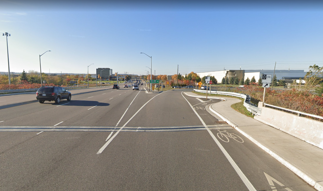
The Dutch do these exceptionally well, and there are a growing number of solutions and examples in the North American context (like this one in Davis, CA), but solutions are still far from formalized or widespread, and most interchanges still require pedestrians to cross high-speed ramps – a challenging task for an able-bodied adult, let alone a child or someone with sight loss.
What will happen in 2025: The Transportation Association of Canada (TAC) will hopefully reach its funding goal and start on a study on Active Transportation Facilities at Interchanges. This will compile some national and international best practice examples and attempt to layout guidance for the design of better interchanges.
#3: Staged Pedestrian Crossings
A staged pedestrian crossing is one where multiple pedestrian signals are used to allow a person to cross the street, effectively splitting one large signalized crossing into two or more shorter ones. On first read, you might think this is something that would make things worse for pedestrians, and if you look at some of the few examples in Canada today you’d be right, but when done right, these unlock way more flexibility in how we operate signals.
As we build wider and wider streets (some of which with LRTs or busways down the middle), pedestrian crossing distances get longer and longer, and serving those long crossings requires very long signal cycles, which increases delay for everyone (and reduces flexibility to provide transit priority).
Staged pedestrian crossings, combined with more innovative and effective traffic signal programming, will unlock a whole new level for multimodal urban intersections. For an excellent explanation of how they work, see this video from Ontario Traffic Man on YouTube.

What will happen in 2025: Expect to see experimentation on this at the fringes in some more innovative municipalities. I predict we’ll see more study of these in the next couple years and they will make their way into guidelines by the end of the decade.
2025 is full of possibilities for the creation of safer streets and liveable communities! There is a lot of great innovative work being done, abroad and here in Canada, to figure out how we can continue to build integrated cities – ones that work for everyone, at all ages and abilities.

Looking forward to all theses changes! Hope they come to fruition. I’m especially a big fan of Ontario Traffic Man’s videos.
LikeLiked by 1 person
Also, do you know if red arrows in fully-protected traffic signals and better symbolic transit signals (like the white ones seen in Quebec and USA) coming to Canada anytime soon? I’ve heard that the TAC is about to endorse red arrows, but also that the Ontario Ministry of Transportation previously shot them down following a “feasibility study”. I really believe they will be useful in reducing sign clutter. clearing up confusion, and making no turn on red more obvious at certain intersections.
LikeLike
Good questions. Indeed TAC is close to finishing its study of them and I think it’s positive. But each province can still choose its own path. I don’t have any info about transit directional signals unfortunately.
LikeLiked by 1 person
Hi Matt. I’ve experienced the need to cross interchanges over the years and can certainly confirm that it is a scary experience on a bike. I looked at the Davis, CA photo you included in your post but I can’t determine to where cyclists are being diverted. Can you provide a schematic or other illustration to show the route a cyclist would follow?
LikeLike
If you look at the Google Maps link, there is a separated two-way bike lane that runs along the road through the whole interchange.
LikeLike
Thanks Kevin, yep that’s it!
LikeLike
enchanting! Reports Detail [Demographic Trends] and Their Impact on [Social Services] 2025 blissful
LikeLike