

Street design is not neutral: every subtle design detail reflects a community’s values, and comparing designs across communities reveals how those values differ.
Bus Rapid Transit (BRT) has the potential to be a game-changer for communities, especially more suburban ones where high-capacity rail might not yet be viable. Unlike curbside bus lanes, centre-median BRT offers more potential for transit priority by removing all mixing between buses and cars. This enables traffic signals to be operated more efficiently to prioritize buses.
It’s interesting, then, to see this concept of centre-median BRT implemented in different ways, by three different jurisdictions in the same province of Ontario.
I like comparing designs and design standards because they reveal the subtle differences in who and what is valued more and less. They reflect the product of internal bureaucratic debates about things like lane widths and design speeds that rarely make it to the public forum. Design is not neutral; wide vehicle lanes, for example, communicate that comfort and high speeds for motorists are important, while landscaped buffers at the roadside communicate that the pedestrian experience is valued. Final cross sections and alignments reflect the results of a series of trade-offs and competition for space.
In this post, I compare the roadway design elements of three BRT projects currently in the design phase in Ontario and draw my own conclusions about the values reflected in these differences. As a disclaimer, I have had zero involvement in the planning and design of these projects.
The three projects are:
- The Toronto segment of the Metrolinx Durham-Scarborough BRT
- The Pickering segment of the Metrolinx Durham-Scarborough BRT
- The Ottawa Greenbank Road Transitway Extension
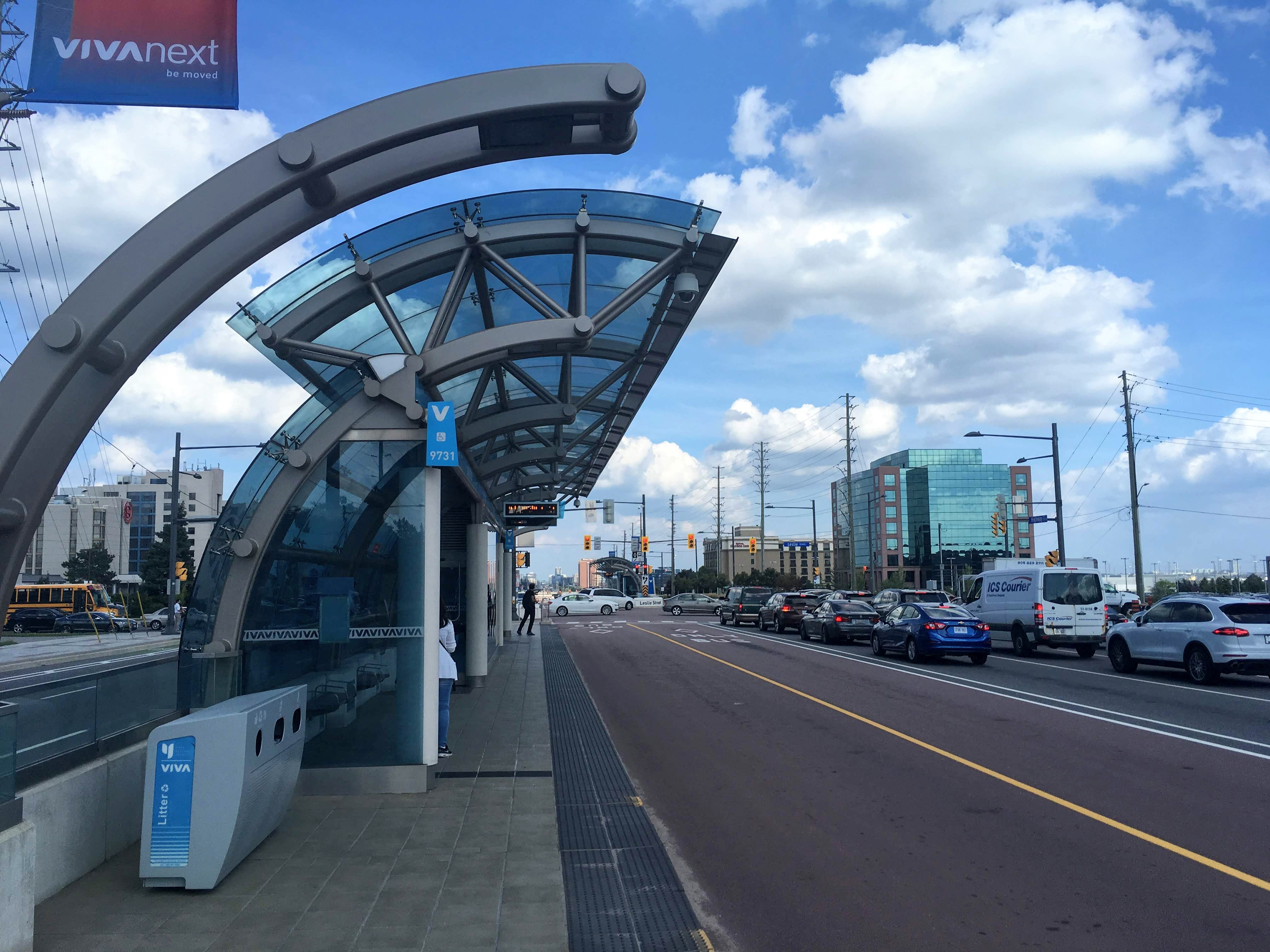
Toronto
The Toronto portion of the Durham-Scarborough BRT travels along Ellesmere Road, a 50km/h primarily four-lane arterial that connects to Highway 2 where the BRT continues for the Durham alignment.

Cross Section
The Toronto portion of the BRT is configured as two 3.5 metre bus lanes running down the centre of the street, with narrow 1.0m medians on each side fully separating the bus lanes from vehicle traffic while providing a space just large enough to place signs and potentially store some snow. BRT platforms are 3.6m wide by 40m long, described by Metrolinx as “open concept shelters, with wind screens for weather protection”.
The City of Toronto is known for having among the narrowest standards for lane widths in Canada, and those are on display here. The curbside vehicle lanes are 3.3 metres and the inside lanes and turn lanes are 3.0m. This combination results in a midblock curb-to-curb width of 21.6 metres.

In the boulevard, Toronto’s generous standard 2.1 metre sidewalks are provided, along with cycle tracks that measure to be roughly 1.8 metres wide. The cycle tracks appear to be consistently set back from the roadway by about 0.8m and the gap between the sidewalk and cycle track varies from 0.8-2.5m. For some portions of the Toronto segment, 3.0m multi-use pathways are provided instead due to constraints.
Alignment
Across the corridor the roadway follows an accordion pattern, fanning out at intersections and compressing inward along midblock segments where turn lanes aren’t needed. This offers several key advantages:
- it helps to manage motor vehicle speed, as motorists have to zig-zag between signals and must pay more attention and keep their hands on the wheel every block
- it creates more opportunities for pedestrian realm, through the creation of 2.0-2.5m wide midblock landscaping zones are in the boulevard that allow planting of green infrastructure and contribute to a better pedestrian experience.
- it requires less overall property acquisition, allowing use of a narrower right-of-way midblock with acquisition focused more at intersections.

The “taper length”, which is the straight length of roadway over which changes in vehicle lane alignment are carried, varies between 50-60 metres, corresponding with a design speed of 50-60km/h. This is aligned with Toronto’s Complete Streets Guidelines which recommend setting the design speed equal to the posted speed.
Pickering
The Pickering portion of the Durham-Scarborough BRT travels along Kingston Road, formerly known as Highway 2. The street already has some transit priority features including enhanced bus stops and bus lanes at some intersections. The existing posted speed is 60km/h.
Cross Section
Two centre 3.5m BRT lanes are still provided, but are instead separated by a 1.7m centre median and not buffered from the adjacent traffic lanes. BRT platforms are 4.2m compared to Toronto’s 3.6m, enough width to provide fully-enclosed shelters.
The vehicle lanes get wider at the municipal border, where Durham Region standards are now applied instead of Toronto’s. They’re still fairly compact compared to Ottawa’s, with 3.35m curb and thru lanes, and 3.0m turn lanes. This combination results in a midblock curb-to-curb width of 22.1m, just 0.5m wider than Toronto’s.
In the boulevard, the street’s existing 1.5m sidewalks are proposed to be widened to 1.8m, a significant step forward for a more suburban municipality, bringing the width in line with the Transportation Association of Canada’s (TAC) recommended width. Cycle tracks are continued into Durham and appear to be 1.8m wide and separated from sidewalks by a minimum 0.8m. Compared to Toronto, the boulevards are much more generous thanks to the much wider overall right-of-way, which varies between 45-49m compared to just 35m on Ellesmere. The boulevards are currently absent of any trees though, and it is unclear whether any specific landscaping measures are proposed.

Alignment
Similar to Toronto, the roadway fans in and out between midblock and intersections, but does so much more gradually. While the Toronto design has 50-60m tapers, Pickering has 100-120m long tapers, corresponding with a much higher design speed. Combined with the radius of the roadway’s curves (570m), I estimate the design speed being applied in Pickering to be 80-90km/h, significantly higher than Toronto’s 50-60km/h. As I’ve discussed previously, this will correspond to higher vehicle travel speeds, more noise, and potential for more severe collisions.
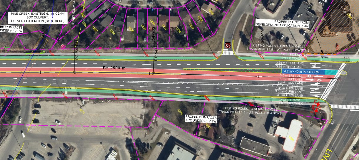
At intersections, even though a very generous amount of property is available, the cycle tracks cross adjacent to the vehicle lanes. I hope that as this design develops and Ontario’s updated cycling design guidance (Book 18) is released that the project team will consider protected intersections with setback bicycle crossings, something that has become a standard in Ottawa.
Ottawa
Ottawa has a rich legacy of building grade-separated, bus-only roadways across the city (known as the Transitway), but is in its infancy in designing centre-median running bus rapid transit streets. Chapman Mills Drive serves as the only presently constructed example in the City, though many more are in the planning process, including the Baseline BRT which I’m particularly excited about. The City is currently engaging the public on designs for the Greenbank Road extension, which will be constructed as a new road with BRT, rather than as a future retrofit.

Cross Section
The roadway portion of Ottawa’s BRT cross section is much more generous. Ottawa’s bus lanes are 3.8m wide (compared to 3.5m), separated from traffic lanes by a median on each side ranging from 1.5m to 4.5m. Ottawa’s BRT platforms are the widest of all at 4.5m, compared to 3.6m for Toronto and 4.2m for Durham. Ottawa’s vehicle lanes are also the widest of all examples, with 3.5m curb and inside lanes, and 3.25m turn lanes. The combination of all of these wide features results in a much larger midblock curb-to-curb width of 30.6m (compared to 21.6m and 22.1m for the above examples). That’s an extra 9m of asphalt and concrete for essentially the same functional roadway.
2.0m sidewalks and 1.8m cycle tracks are provided in the boulevards, with a 0.2m tactile strip separating the facilities, and 1.0m between cycle tracks and the roadway. Green space is entirely absent from the cross section, resulting in a massive hardscaped area.
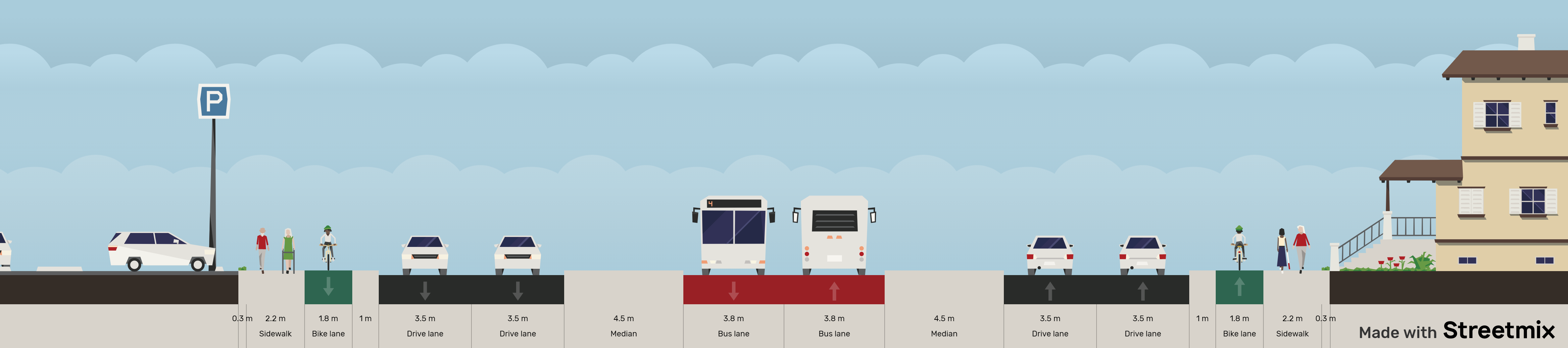
Alignment
While the Toronto and Pickering examples follow an “accordion” pattern between midblock and intersections, Ottawa’s design keeps the vehicle lane alignment straight as an arrow along the roadway. Without horizontal tapers to help govern vehicle travel speed, this will likely lead to higher rates of speeding. It also means there is no space available for landscaping and green features at the roadside, which will lead to a very hardscaped environment with little placemaking potential. Based on the horizontal curvature of the roadway where it bends (380m centreline radius), I estimate the design speed to be between 80-90km/h which, similar to Durham, will likely induce more speeding and noise.

A positive of the Ottawa design is its commitment to protected intersections, which are provided at all signals. The setback crossings, combined with pedestrian refuges, lead to safer crossings for vulnerable road users and a shorter roadway crossing distance for pedestrians. I look forward to seeing these designs refined as Ottawa finalizes its Protected Intersection Design Guidelines this summer.
Another differentiator for Ottawa intersections is the absence of right turn lanes at signalized intersections. Whereas the Toronto and Pickering designs fan out to accommodate a right turn lane, Ottawa’s design does not, allowing it to require less right-of-way, with more space for pedestrian and cycling facilities in the corners.
Conclusions
These three examples demonstrate that, even in the same province, designs still vary widely based on local preferences and values. Here’s a few takeaways for me:
- Cycle tracks are here to stay: raised, in-boulevard cycle tracks are present in all designs. This reflects a consistent commitment across Ontario to provide cycle tracks, rather than bike lanes, on arterial roads. In Durham especially, I hope to see the intersection designs updated to include protected intersections with setback crossings.
- Significant variation in lane width standards. Though all streets are in the same province, governed by the same vehicles and regulations, Ottawa’s lanes are much wider. This reflects the differences in these regions’ priorities; Toronto is accustomed to building in constrained right-of-way environments, while Ottawa is still building new roads and has wider right-of-ways.
- The “accordion” model for roadway design used in Scarborough and Pickering is more space efficient, better for managing vehicle speeds, and allows the creation of more landscaping in the boulevards without needing more right-of-way. Toronto’s 35m wide corridor will have substantially more landscaping than Ottawa’s 41.5m wide corridor.
- Regional variations reflect different values. Toronto is a city used to doing more with less, in constrained right of ways, and now uses narrower lanes by default, creating more space for everything else. Toronto’s commitments to complete streets, green streets, streetscaping, and Vision Zero translate to slower vehicle design speeds, wider sidewalks, and more green infrastructure. Meanwhile, Durham and Ottawa’s designs reflect these municipalities’ commitment to faster vehicle speeds based on the mentality that faster design speeds with wide clear zones create safer streets. While Durham has wide boulevards thanks to generous a generous right-of-way, it’s not clear whether they plan to add landscaping or urban design features. Ottawa, meanwhile, has identified no space for green infrastructure in its corridor despite having 6.5m more space to work with than Toronto.
Want to enjoy more content like this? Join the Beyond the Automobile mailing list to be notified of new posts. Disclaimer: I was not involved in any of the designs discussed in this post.


In regards to the Ottawa one, not having right turn lanes at traffic signals has a major downside. If right turning and through traffic shares a lane, it means that you can’t give right turning traffic and through traffic different signals. So you can’t really hold back right turning traffic when pedestrians and cyclists have a green light or give right turning traffic a green right arrow when cross traffic has a left turn signal.
LikeLike