
Redesigning places to better support safe, comfortable walking and cycling is not hard, and often the tools needed already exist at the local level. It just requires a little bit of imagination!
Transportation objectives of countless cities around the world are changing, from being automobile-oriented to more multi-modal. This shift in mindset will result in streets that are safer and more pleasant for the surrounding community and those who travel through, but the street-level transformation can often be the hardest part. It requires unlearning many fundamental assumptions we have applied to streets and street networks over the past century (like smooth, uninterrupted flow of cars). It involves new and experimental methods, and most importantly, it involves curbing the dominance of the automobile on streets.
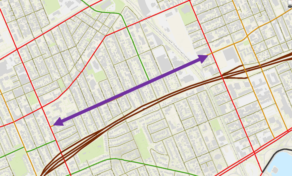
Ottawa’s Gladstone Avenue is a street I travel often, and one of many streets that could use some reimagining, so I decided to develop an alternative design for it. Old aerial photos from GeoOttawa reveal that this roadway has changed very little in decades, aside from a few tweaks here and there. For the scope of this reimagining exercise, I’ve chosen the segment of Gladstone from Parkdale to Preston, a stretch of about 1.4 km (0.9 mi). I cycle on this segment frequently and though it has potential to be a high-quality cycling connection, its current condition is very lacklustre.
In this post, I’ll go through a condensed version of the design process to imagine a new configuration for this street. I’ll document the existing conditions, form a problem statement and design objectives, provide my proposed design treatments, and end with some conceptual illustrations of what the design could look like if implemented. Finally, I’ll provide a list of methods, sources, and inspirations for the design.

Existing Conditions
Cycling
Gladstone Ave is designated as a “spine” cycling route, but despite this, vehicle speeds and volumes are higher than what is comfortable for an average cyclist, and certainly not appropriate for a child. NACTO recommends that comfortable conditions for an all-ages-and-abilities cyclist to operate in mixed traffic are less than 2,000 vehicles per day and an operating speed of 30 km/h (20 mph), two conditions that Gladstone is far from meeting. Despite all this, however, cycling volumes at intersections along the corridor range from 400 to 600 per day, accounting for as much as 8% of total vehicle volumes. Finally, the Trillium Pathway, a high-volume walking and cycling route, crosses Gladstone at the east end, functioning as a major link in the local cycling network.
Walking
The transit service and walkable grid plus the many destinations in the area (especially along Somerset) make Gladstone a main route for walking, and the many single-family homes in the area mean children are often present. Despite this, the narrow sidewalks with no buffer from the street, frequent intersections, and higher travel speeds leave little room for error for a person on foot, regardless of ability.
Transit
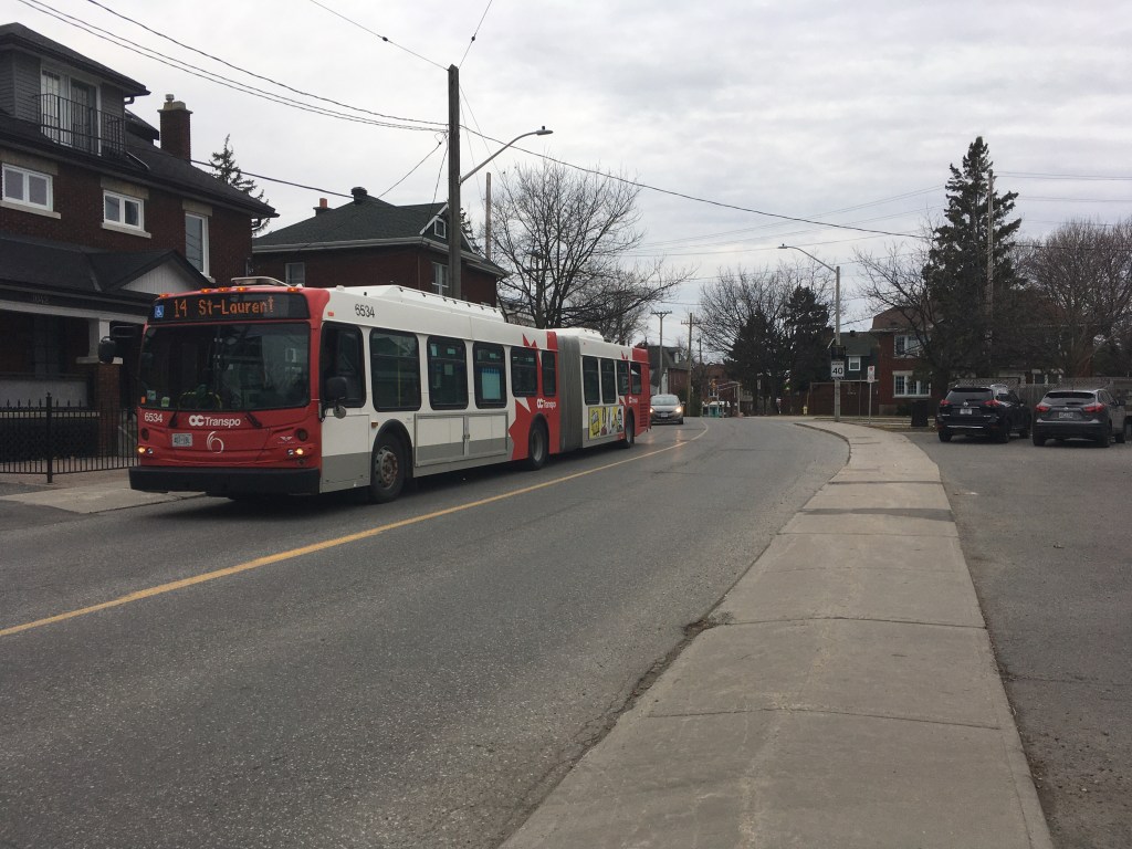
Gladstone serves as an important transit link, forming part of OC Transpo’s frequent transit network where buses operate at least every 15 minutes in both directions from 7AM-6PM. More importantly, the new Gladstone LRT station on the Trillium Line (Line 2) is currently under construction, planned to open in 2022. This station will facilitate a significant amount of new transit-oriented development in the area, which is currently being planned under the Gladstone Station District Secondary Plan.
Motor Vehicles
From a motor vehicle perspective, Gladstone is classified as a “major collector”, which the City of Ottawa defines as a street intended to “serve travel between collector and arterial roads”. As a result of this classification, as well as its continuity eastward, Gladstone carries a significant amount of crosstown traffic in addition to the local community connections. The posted speed is 40 km/h (25 mph), but by standing at one of the radar detectors installed on the street and surveying speeds, I am able to approximate the average speed to be around 45 km/h and the 85th percentile speed to be closer to 50 km/h (30 mph). This is not ideal for cyclists riding in mixed traffic.
The 85th percentile speed is referred to as the operating speed of the street, and is typically used to set the posted speed limit. When the operating speed is higher than the speed limit, speeding is common.
Based on intersection traffic counts published by the City and some of my own assumptions (see my notes at the end of this post), I estimate the street carries between 4,500 and 6,000 vehicles per day along this segment. The road width is narrow as far as Ottawa collector streets go, ranging between 7.5 and 9.0 metres (24-30 feet) based on my measurements taken from Google Earth.
Problem Statement
With all of this in mind, I find the dominant problem of the street to be a substandard level of service provided for pedestrians and cyclists, with very limited options to improve facilities for these modes through widening. I also suggest that the “major collector” classification of the corridor is inappropriate, and that the purpose of the roadway from a vehicle perspective should be to carry motorists from local streets to arterials and other collectors, rather than serving as a link between surrounding arterials.
The key difference between major collector and collector roadways is the former is also intended to carry traffic between arterial roadways (essentially acting as a thru-way), while the latter is only intended to carry traffic from local streets to arterials and back.
Design Objectives
With the problem statement in mind, I am setting out to reimagine Gladstone with the following objectives:
- Reduce motor vehicle volumes from the current 4,500-6,000 per day to 3,000 per day, to reduce level of stress for pedestrians and cyclists and improve “crossability”
- Reduce vehicle speeds to 30 km/h (20 mph) for the full segment to create more comfortable conditions for cyclists mixing with motor vehicle traffic
- Provide comfortable and frequent crossing opportunities for pedestrians across Gladstone and across intersecting streets
- Maintain efficient transit operations and emergency vehicle access
- Facilitate motor vehicle access between local community and surrounding arterial and collector streets
- Provide a solution that is feasible within the narrow right-of-way and that is not cost-prohibitive
Proposed Design Treatments
Based on the above design objectives, I have developed a design concept for the roadway, which I will discuss under multiple headings. Keep in mind that this solution is one of many possible ones for this street, and is based on the problem I have identified. Others will likely have differing ideas as to how the street could be improved (and I invite you to share your ideas in the comments at the end of this post!).
Traffic Management
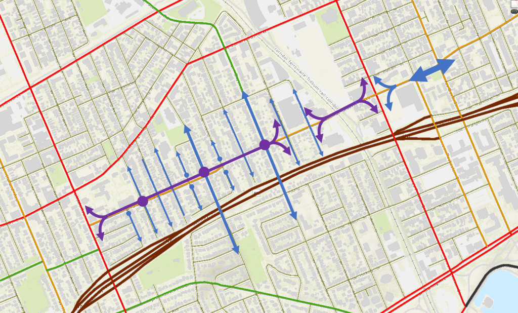
Traffic management is the act of consciously deciding where motor vehicles will travel within the road network, and is the most effective tool for meeting the objective of volume reduction to 3,000 vehicles per day. These measures will direct some vehicle traffic to other streets in the network, but will also facilitate a shift in the modes that people use, by making walking, cycling, and transit more attractive.
- Downgrade Gladstone from “major collector” to “collector”, removing this street’s purpose of carrying through traffic between arterials (Preston and Parkdale)
- Divide the segment into an east and a west zone and implement a transit-only “choker” on the east side of Breezehill, with bicycles and emergency vehicles excepted. An example this design in Ottawa can be found here
- Prohibit eastbound and westbound through movements at Preston, either all day or during peak hours, with transit and emergency vehicles excepted at all times
- Implement vehicle access closures for side streets where secondary access is available (Beverley, Irving and St Francis)
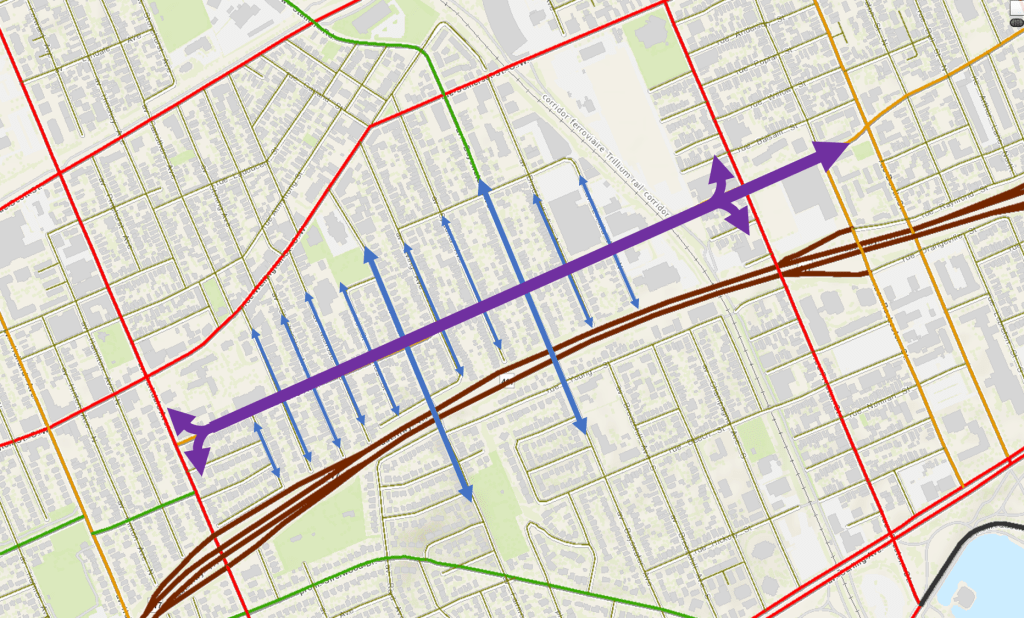
The proposed changes are visualized in the two diagrams below showing the existing and proposed traffic circulation plans.
Traffic Control
This category refers to the method of control applied at intersections and crossings. There are currently two traffic signals within the corridor (excluding the ones at the ends), and with a reduction to 3,000 vehicles per day on Gladstone these will no longer be necessary as a traffic control measure (they may not even be warranted under existing conditions).
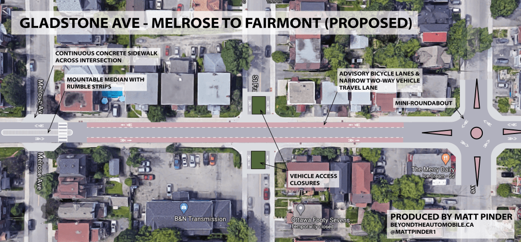
- Remove all-way stop at Rosemount and remove traffic signals at Bayswater and Fairmont
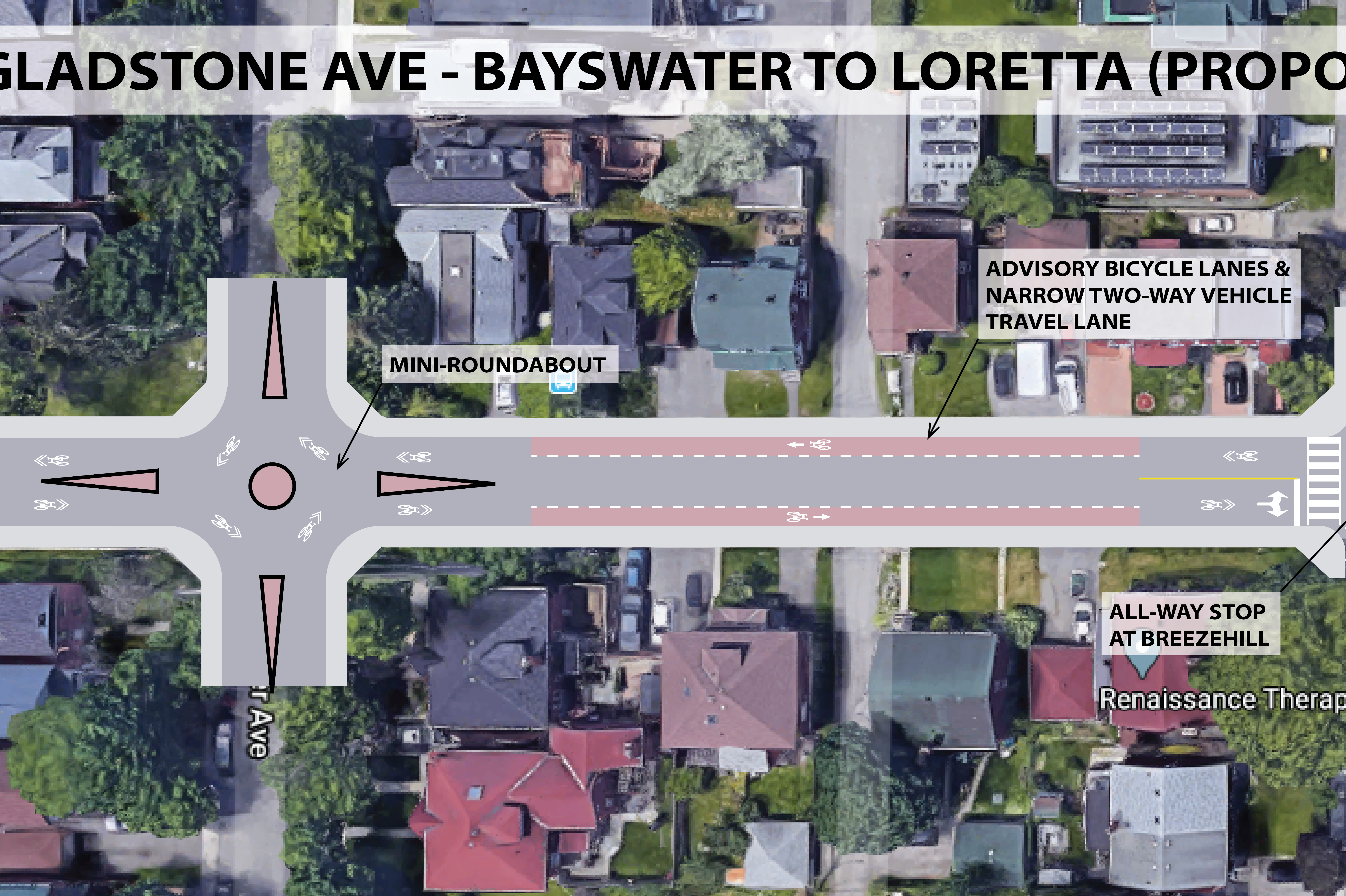
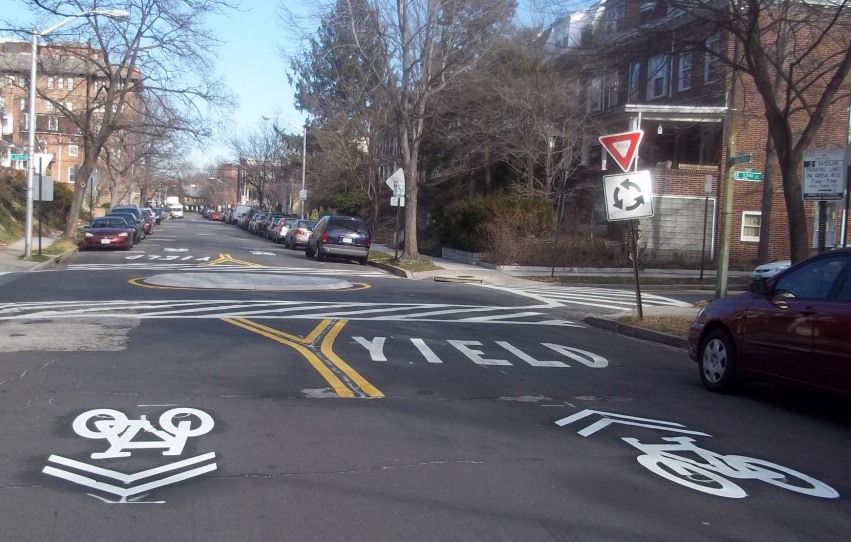
- Provide mini-roundabouts (photo below) at the Rosemount, Bayswater, and Fairmont intersections, which provide smoother and slower vehicle flows
- Add an all-way stop at Breezemount, where the choker is proposed
- Provide midblock pedestrian crossings every 100 to 200 metres (300-600 ft), with mountable splitter islands (photo below) to slow vehicle speeds and improve motorist yielding rates

Speed Management
This category summarizes the measures aimed at achieving the target motor vehicle operating speed of 30km/h on the corridor. The removal of most of the stop signs and signals on Gladstone means that, even at a lower posted speed, the average speed for motorists along the corridor will likely be unchanged, or may even improve.
- Mini-roundabouts and splitter islands provide horizontal deflection
- Motor vehicle lane widths reduced to minimums at mountable splitter islands
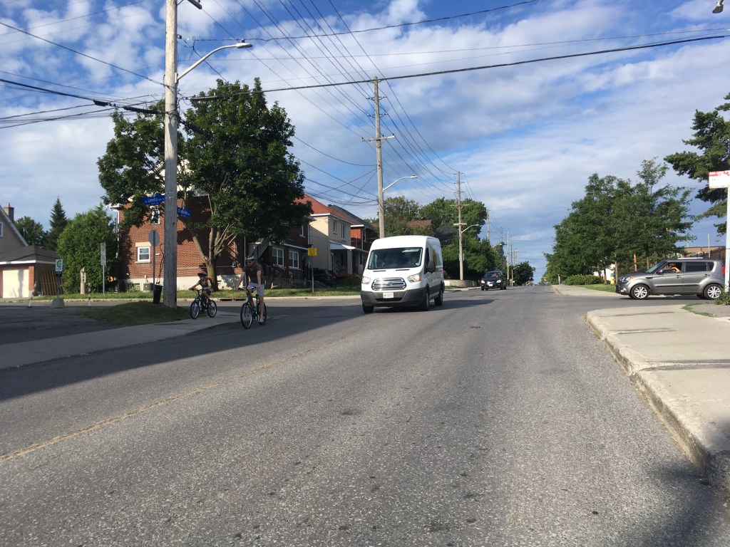
- A narrow two-way travel lane for motorists where advisory bicycle lanes are present, requiring motorists to yield to oncoming traffic
- Reduce posted speed limit to 30 km/h, a measure that can only be safely implemented after the above speed control measures are in place
Walking Improvements
The narrow right-of-way of this street reduce the available options for improving walking and cycling. Still, I’ve chosen solutions that are proven to work in constrained environments in conjunction with lowered motor vehicle volumes and speeds.
- Continuous concrete sidewalks across side streets, rather than breaks, to clearly communicate right of way to pedestrians
- Selective side street vehicle access closures, to further reduce vehicle cross-traffic, while keeping a permeable grid for pedestrians
- Reduced vehicle volumes to increase “crossability” of the roadway, a term that the CROW manual uses to describe how easy it is for someone to cross a street at any point, and how long they likely will need to wait for a gap in traffic.
- Provide midblock pedestrian crossings every 100 to 200 metres, with mountable splitter islands to slow vehicle speeds and improve motorist yielding rates

Cycling Improvements
Even with significant volume reduction, it is likely that the design cyclist will still experience discomfort cycling in mixed traffic along the street, so some cyclist priority measures are required.
- Advisory bicycle lanes intermittently along the corridor (example from Ottawa in photo below), which require motorists to share a narrow centre travel lane while cyclists have priority use of the curb lane
- Horizontal deflection for motorists at mini-roundabouts and pedestrian crossings, which require motorists to move over on the roadway while cyclists continue straight

Design Illustrations
Now to bring all of the concepts to life!
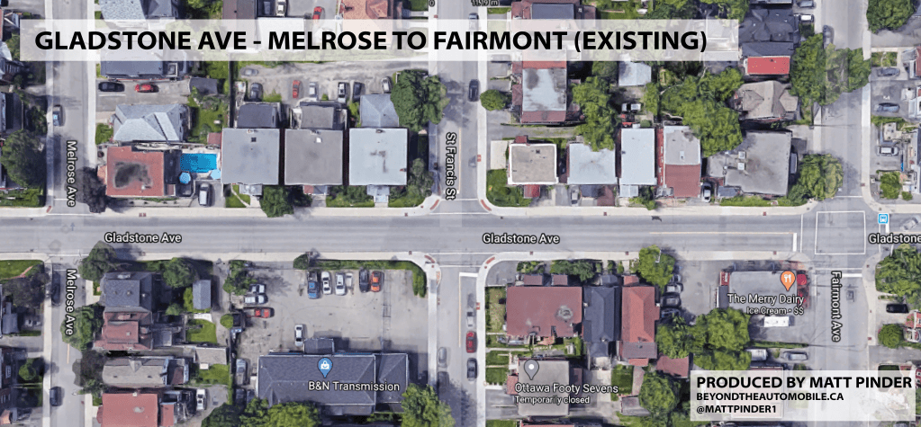
To demonstrate the proposed design solutions, I developed conceptual plan designs for three segments of the corridor. Existing and proposed conditions are shown.
Melrose to Fairmont
Bayswater to Loretta


Trillium MUP Crossing


Final Thoughts
The proposed design concept is feasible within the existing constrained right of way, and involves only minor changes to curbs, rendering it an affordable solution that could likely be paired with a resurfacing of the roadway (which the street will be due for soon).
As far as accommodating transit, I am unsure how transit vehicles would traverse mini-roundabouts. One potential solution is to provide a “track” down the middle of the centre island to allow transit vehicles to pass straight through without following the circular path. Of course, if acceptable, transit vehicles could also simply mount the centre island.
The final illustration, showing the Trillium MUP crossing, is another complex aspect of the design. The new LRT station will be adjacent to this crossing and will even create more pedestrian and cycling crossing demand in the area. Sightlines need to be fully evaluated to determine whether pedestrians or motorists should have priority at the crossing, but the essential elements (motor vehicle speed and volume reduction) are present in the design shown.
There you have it, an affordable, workable solution for a constrained corridor that will deliver significant improvements to the walkability and bikeability of this corridor, helping to feed more users to transit and especially the planned Gladstone LRT station.
Do you have thoughts or feedback to offer on the design? Feel free to leave a comment below. Plan view images can be directly downloaded here.
Methods and Sources
Disclaimer: these designs reflect my own opinions, as a transportation professional, of one potential redesign of this street. The design does not necessarily reflect the views of my employer and does not constitute professional advice. I endeavoured as much as possible to provide a solution that would be achievable within the preferences and guidelines of the City of Ottawa.
- I drew inspiration for this design from this suburban Dutch street in a town outside of Amsterdam
- Mini-roundabouts are designed generally in accordance with City of Ottawa published guidance
- I used the City of Ottawa Traffic Calming Guidelines as a source of traffic calming measures
- I sourced traffic data for Gladstone from the City of Ottawa open data website. To convert from intersection volumes to volumes exclusively on Gladstone, I made the following assumptions for the percentage of intersection volumes attributed to Gladstone: Parkdale (30%); Rosemount, Fairmont, Breezehill (70%); Bayswater (60%); Preston (40%)
- To estimate the operating speed of the roadway, I observed the speeds displaced on the the digital speed radar detector installed at Gladstone and Irving Ave as vehicles passed. I stayed long enough to observe 11 motorists (a limited sample size, I’ll admit), with an average speed of 45 km/h. Fitting the data to a normal distribution, I inferred the 85th percentile speed to be 49 km/h.
- Advisory bicycle lanes are designed based on the findings of this Alta Planning+Design whitepaper. Ottawa also has implemented this facility type here.
- The transit-only choker feature is based off of this one that was built in Ottawa in the 1990’s
- Ottawa has many examples of continuous concrete sidewalks at intersections. See here, for example. The Dutch do this treatment much better though, and as a standard practice. Here’s an example of that.

Maps are too small. With no readable street names, I can not see where that is.
LikeLike
Sorry you’re having trouble viewing them. At the end of the article I provide a direct link to download the images, which should hopefully address the issue you’re having.
LikeLike